Ha Giang Loop: Extreme North Travel Guide
00
02
Hà Giang is Vietnam’s northernmost province. Once considered the final frontier for adventurous travel in Vietnam, this borderland has since gained legendary status among independent travellers, principally for a motorbiking itinerary through otherworldly landscapes, known as the Hà Giang Loop. Main roads meander past rippling rice terraces, mountain passes cut cliff faces above turquoise rivers and countryside lanes thread through forests of limestone pinnacles. Hà Giang is also home to more than a dozen ethnolinguistic groups, each with their own language, architecture, apparel and way of life. In recent years, visitor numbers on the Hà Giang Loop have increased, road conditions have improved and tourist services have proliferated. While some road sections can get busy with motorbike convoys, mass tourism has not arrived….yet. Now is the time to ride the Hà Giang Extreme North Loop.
Riding the Legendary Landscapes of Vietnam’s Extreme North
This guide is intended for independent motorbikers, but it should also be useful for cyclists, motorists and any travellers trying to design a tour of the Hà Giang Loop with a driver or company. My route map features the main loop and several side routes and extensions. In the Overview & Details section, you’ll find useful, need-to-know information, such as weather, motorbike rental, duration and distance, accommodation, food and drink, police and permits, as well as a general outline of the route. For each section of the Hà Giang Loop, I’ve written a detailed description, including recommendations of places to stay and eat, sights and excursions along the way, and much more. There’s a separate section for Hà Giang City, as this is where most travellers will start and end their trip:
Hà Giang City
Hà Giang, the provincial capital, is a likeable city on the banks of the Lô (Blue) River which, despite its name, usually runs muddy and brown. It’s a comfortable place to prepare for the loop and relax and recuperate after the ride. There are a lot of good accommodation options near the two main streets on both sides of the river: Nguyễn Trãi Street on the west bank and Nguyễn Thái Học Street on the east bank. For peace and quiet, there is a cluster of hotels in the neighbourhood immediately north of the central square (Quảng Trường Thành Phố Hà Giang), such as the very comfortable Luxury Hostel (it isn’t luxury or a hostel, but simply a well-run and good value guesthouse). Overlooking the square are Mị Homestay and Nhật Bảo Hotel, which offer views of the square but are noisy on weekends. There’s more choice on the other side of the river, such as the cheap and cheerful Tiamo and the Sky Building, which has a bizarre but comfortable café-cum-hostel overlooking the river. For something a little more upmarket, try Hà Giang Historic House or Phoenix Hotel. There’s also a cluster of hotels and homestays immediately south of the bus station, which feels like the countryside even though it’s a few minutes’ drive from the city. The two private rooms at Homestay Field are highly recommended, and the charismatic owner can put together delicious dinners at a moment’s notice. Two well-run accommodation options north of town are NoMadders and Flipside Adventures.
When it comes to food, you’re spoilt for choice (at least compared with the rest of the province). For breakfast, the bánh cuốn (wet savoury pancakes) at Bánh Cuốn Quảng Trường Hà Giang may be the best in town. Just around the corner on Nguyễn Trãi Street is a handful of decent phở restaurants. For lunch or dinner, try the restaurants overlooking the central square or in the neighbourhood south of it close to Luxury Hostel. There are also many eating options along Nguyễn Thái Học Street, including a beer bar (Nhà Hàng Phố Beer), an upmarket restaurant (Bếp Việt) and surprisingly good pizza (Pizza Here). For vegans and vegetarians, there’s Hương Sen. You’ll find good Vietnamese coffee (and not so good Western coffee) at Trung Nguyên and Lofita. For a drink with a view, ride up to Cafe Núi Cấm, which is also the starting point for the climb to the viewpoint (see below). A good place to buy supplies for snacks and picnics on the road is Ha Giàng’s big central market.
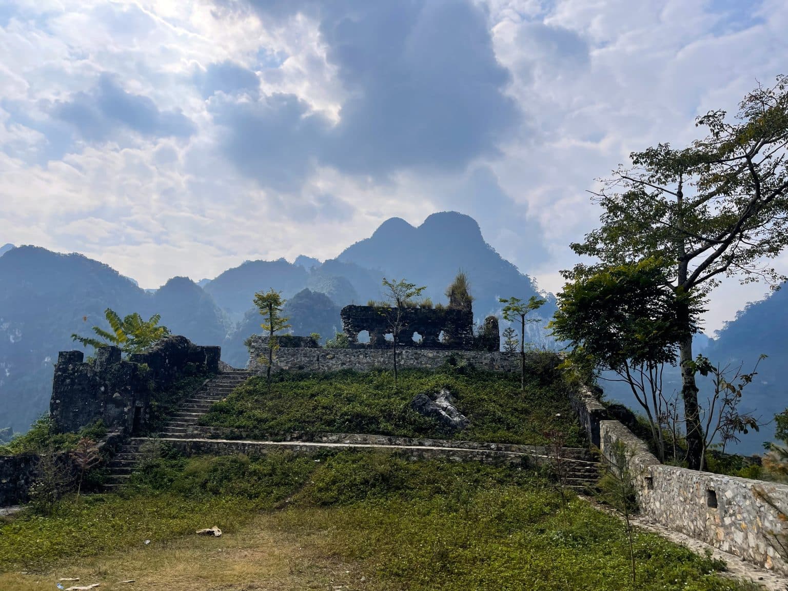
You might hear that there’s nothing to do in Hà Giang City. This is nonsense. Strolling the central square (Quảng Trường Thành Phố Hà Giang) and around, visiting the provincial museum, and climbing up to explore the city’s French fort and viewpoint will easily fill an afternoon.
Section 1
Take Road QL4C north out of Ha Giàng towards Tam Sơn. It’s only a few kilometres before forested limestone mountains tower over you and pretty blue rivers (depending on the season) run alongside the road. The real drama begins after about 30km, at which point you’ll see a sign for Tham Luồng Cave, which is worth a stop if you’re taking it slow and you’ve not seen a limestone cave before. (Note that this stop will add about an hour to your journey and involves climbing a lot of stairs.)
Ride up Bắc Sum Pass, which offers fabulous views back in the direction of Hà Giang City, until the road levels out and you reach Bình An Linh Từ Shrine, dramatically situated on a hill and an excuse to stretch your legs. Continue past a rare example of a Bố Y homestay (the Bố Y ethnolinguistic group only have a few thousand members in Vietnam) before the road begins a long, snaking ascent up to Heaven’s Gate Pass.
After crossing a treeless plateau, Heaven’s Gate Pass drops down to the town of Tam Sơn, nestled in a valley between dozens of conical hills. Near the top of the pass there’s a viewing point with a coffee shop and a few maps of the area. Climb the steps behind the cafe to a small gazebo for unobscured views of the entire district. Ride a little further to view the so-called “Fairy Bosoms”, which have become an iconic symbol of the province for Vietnamese tourists.
Despite its scenic location, the town of Tam Sơn (known locally by the district name Quản Bạ) is a fairly prosaic place. Most people simply stop for some lunch at the popular Yến Ngọc Cafe before continuing on the road. Should you feel like stopping for the night, head to the Dào village of Nặm Đăm, where there are now tens of homestays. This is also where you’ll find Dào Lodge, a boutique guesthouse, but it’s been poorly managed for years. The guesthouse was built by 112 Architects, a Hanoi-based firm that draws inspiration from indigenous architecture to design modern buildings. Instead of staying overnight here, order a coffee and enjoy the architecture from the courtyard.
Section 2
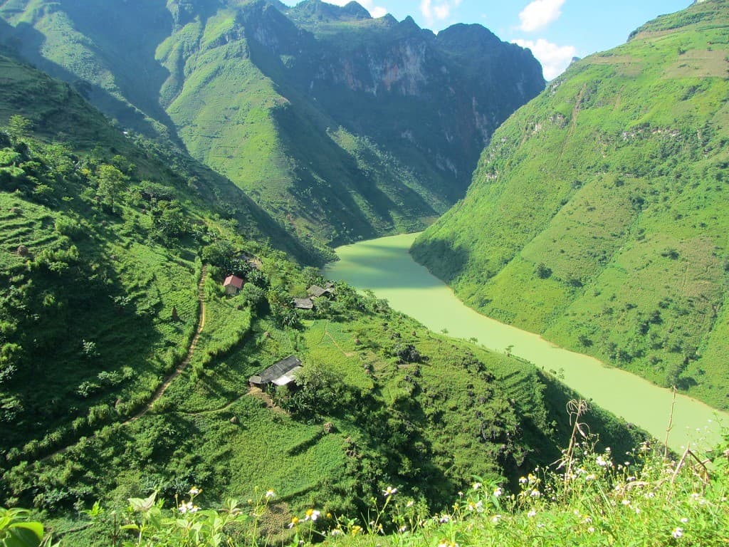
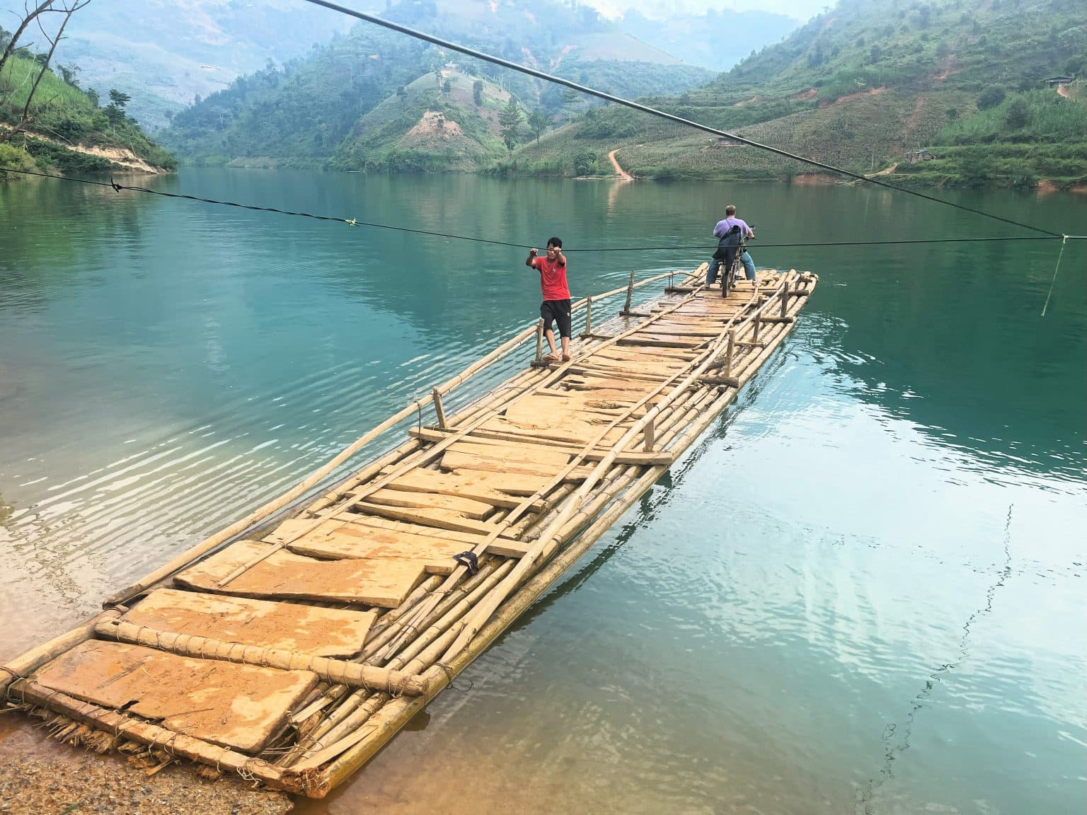
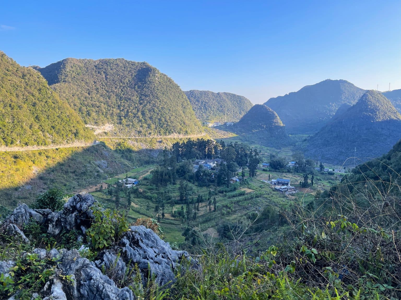
From Tam Sơn, continue on Road QL4C east down to the Miện River valley. At the end of a series of switchbacks (affording yet more stunning views), the road crosses the river on the Cán Tỷ bridge and then you have a decision to make: either stay on QL4C (the blue line) heading due north for the quieter, longer route, passing more hamlets, Cán Tỷ Fort, a pine forest and views of rice terraces; or bear right (due east) just after the bridge for the busier, shorter and more dramatic route (the red line), climbing immediately, passing an ancient tree and some excellent viewpoints. Which road is better? It’s hard to say. Perhaps take the longer road (QL4C) in the spring and summer months when the rice terraces are green and bulging, but take the shorter route in the autumn and winter months when the landscapes are starker.
Whichever route you take, when you descend into Yên Minh you’ll see the limestone forests of the Đồng Văn Plateau in the distance, looking like the crenulated ramparts of a giant castle. Yên Minh is another small, dusty town in a basin surrounded by great limestone pillars. Although it’s not a particularly charming place to stay, it’s a convenient stop and the main street has a few hotels to choose from. Try Bống Bang Homestay 2, which also serves up delicious food in their leafy garden away from the road.
Section 3
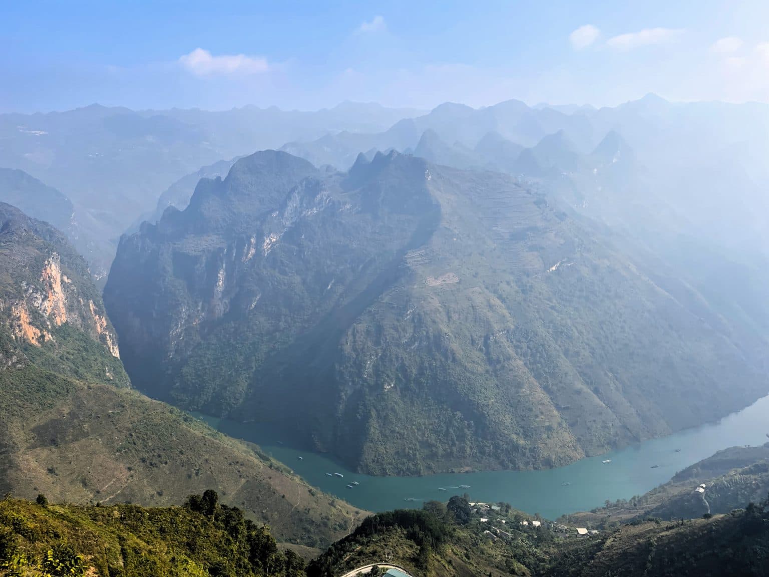
The scenery gets even better north of Yên Minh. Road QL4C ploughs through an undulating landscape of dramatic peaks and troughs, formed over millions of years by tectonic activity and erosion. Pinnacles rise and fall at regular intervals, and the shapes are so live and animated, it’s as if the landscape were in fluid motion until it was suddenly petrified, like a frozen sea. The roads that cut through the terrain are as impressive as the topography. In the last few years, dozens of small, paved lanes have appeared, criss-crossing the entire area. These offer tempting diversions, leading to isolated villages and towns hidden deep within the landscape.
The people who inhabit this region are predominantly mountain dwelling ethnolinguistic groups, particularly Hmông. For them, this rocky, treeless land offers little protection from the elements, and crop yields are limited because of the lack of fertile soil. Travellers who’ve come from Sapa, may find minority people in this region less forthcoming when compared to the business-savvy people in the northwest. However, children all along this route will skip and jump down the road screaming “Hello!” and occasionally put their hands out for money. You might keep some small, nourishing snacks to offer these children as an alternative to money. Children may also pose for photos and then ask for money. This is a dynamic which has made social interactions between foreign visitors and local people in more touristy areas like Sapa increasingly uneasy.
A couple of minutes due east of Yên Minh, the road forks. Bear left (due northeast), continuing on QL4C towards Đồng Văn. A steep pass takes you immediately into the limestone karsts. Trees are noticeably absent from the rocky slopes, and there are no more terraced rice fields and fertile valleys. Instead, you’ll see acres of soybean plantations, punctuated occasionally by clumps of corn. Many older structures are made of mud bricks or blocks cut from the limestone. Walled hamlets shelter in the tight clasp of conical hills.
After cutting along steep, treeless valleys, the road winds up Dốc Thẩm Mã and then the Nine-Turn Pass. A helter-skelter stretch of tarmac, this pass is a favourite photo-opportunity for road-trippers. From the top, you can see the road snaking down to a flat valley encased by limestone karsts. A little further on, a left turn (due north) offers a short side route heading to Phó Bảng, a predominantly ethnic Chinese town. This add-on is well worth the time and effort, especially in October, when the purple, pink and white buckwheat flowers are in bloom. Phó Bảng’s old town is very special, with several terraced houses built in a distinct Chinese style. Otherwise, continue on QL4C past a little Hmông village that receives a constant flow of domestic tourists thanks to being the filming location of the popular 2006 movie Story of Pao. After passing this heavily touristed village, there are opportunities to leave the main road and explore more authentic (less touristy) Hmông hamlets via side roads, such as the one to Lao Sa (also written Lao Xa). Here you’ll find a very special homestay in an ancient Hmông abode.
Back on QL4C heading due east, after more glorious scenery there’s another fork in the road at Sà Phìn. You’ll bear left at the fork (signposted to Lũng Cú and leaving QL4C), but first, continue south for a few hundred metres to visit the former palace of the Hmông king (entrance is a couple of dollars). One of the most compelling heritage sites in the province, this attractive stone and timber structure was built by the French colonial administration to appease the Hmông king. He had a fearsome reputation and considerable wealth, gained from growing opium poppies in the area. The palace’s three stone courtyards and tiled rooftops look like a set from Crouching Tiger, Hidden Dragon. Outside, there’s a local market selling seasonal produce: in the autumn there are walnuts, chestnuts and star anise for sale. The palace is signposted off the main road, down a steep lane leading into the valley.
*Note If you decide to skip the next part of the route to Lũng Cú, ignore the rest of this section and jump to the second paragraph of Section 4 instead.
Leave the king’s palace and backtrack a little to the fork, then head due north to Lũng Cú, Vietnam’s North Pole. This is a popular pilgrimage for young Vietnamese groups, who make the trip on motorbikes from Hanoi. At the Khe Lia Panorama, continue due north on the Lũng Cú road. After a few kilometres you’ll see signs to the Giấy village of Má Lé, which also has a special homestay in a breath-taking two-floor house made of stone and wood (although the service here is questionable). A fun curiosity of the homestay, which presumably has had funding from UNESCO, is the tiny brachiopods museum, which holds fossils from the area. The museum isn’t impressive or informative, but its perplexing existence in such a remote part of the country is worthy of some admiration. Further on, the road briefly runs parallel to the Chinese border. The border appears fluid and unguarded. Motorbikes cross over to China and back again, passing a sinister milestone with black skull and crossbones next to a few red-painted Chinese characters. Do not attempt to cross the border.
Marking Vietnam’s northernmost point in Lũng Cú is a tall flag tower atop a small hill with excellent views across to China. (Sticklers may wish to note that Vietnam’s true northernmost point is a few kilometres north of the flag tower.) Entrance costs a few dollars and you can pay an extra dollar for an electric buggy to take you most of the way. The village of Lô Lô Chải is close by and has several homestays, some of which are a little like rustic boutique hotels. Lô Lô Paranoma (presumably a misspelling) is family-run, friendly and has an outdoor terrace with unrivalled panoramas/paranomas. Homie Homestay is also friendly with dorm beds and private rooms. Long Cư Homestay (another misspelling?) is more like a hotel with a handful of elevated bungalows. Lô Lô Chải is inhabited by the Lô Lô, a small ethnolinguistic group famed for the quiltlike apparel worn by the women. The village is pretty, but unfortunately it’s hard to know which houses are genuine heritage buildings that exhibit traditional Lô Lô architecture. I’ve been here several times over the years, and each time the village seems to have a new cluster of homestays crammed into its narrow alleyways.
Section 4
The road from Lũng Cú to Đồng Văn is straightforward. Retrace your steps to the Khe Lia Panorama, at which point you’ll head east on DT182B for the rest of the journey. Alternatively, consider heading back west from Khe Lia Panorama to the Hmông kings palace at the junction with QL4C and then rejoin the road east to Đồng Văn (the red line on my map).
From the palace, QL4C heads east along a serpentine 15km road that coils around limestone pylons. The road is chiselled out of the mountains, gripping to the side of rocky cliffs. Various countryside lanes may tempt you to explore further as they meander up from the road before being swallowed by the clouds or hills. All along this road there are women and girls – from as young as 10 to as old as 80 – carrying heavy loads of wood, hay, and crops on their backs. The bodies of the older women have been permanently distorted, so that their backs are almost at right angles to their legs, even when walking unburdened.
Dồng Văn feels dusty and sprawling until you get to its old quarter, which offers some charm despite a row of fake heritage houses that host restaurants, cafes and hotels. Đồng Văn is one of the most popular towns on the loop and there’s a distinctive touristy vibe, but there’s also plenty to see and do. The district museum wasn’t complete at the time of research, but the large building, which you’ll see before you arrive in town, looks promising. Rice terraces and vegetable gardens encircle the attractive Quan Hoàng Temple, which is close to a storied water god shrine. Legend has it that this area was impossible to farm until a god showed Tày settlers (an ethnolinguistic group) the valley’s water source. To thank him, the Tày people built the shrine. Stretch your legs by climbing the Đồn Cao Fortress, which was built by the French at the turn of the 19th century and offers panoramic views.
There’s a clutch of good places to stay and eat in Đồng Văn. Làng Nghiến Homestay and Nhà Cổ Homestay 1925 are two good budget options; the former is cleaner and more practical, the latter is more atmospheric. H’mong Coffee & Motel is a step up and run by an exuberant team of young Hmông. More high-end accommodation options include Đồng Văn Eco Stone House and Đồng Văn Cliffside House. If Đồng Văn’s touristy inclination doesn’t appeal, consider booking a room at Thiên Hương House, a 20-minute drive north of town. Vegetarians and non-vegetarians alike can tuck into carefully prepared Vietnamese food at Toto Chan. There’s also excellent Vietnamese food served with a smile at Ethnic House. For cheap street food served throughout the day, simply wander down the main road west of H’mong Coffee & Motel.
Tuyen Quang
Why you should choose us?
We have Vietnam tourism license
We have good agencies
We try make you happy


